Magellan
Astro-inertial navigation without GNSS
A new era for autonomous navigation
MAGELLAN is an innovative navigation system that combines heavenly recognition automated and inertial unit high precision. Designed to provide reliable, signal-independent positioning GNSS (GPS, Galileoetc.), it has established itself as a benchmark solution for navigation in contested or degraded environments.
Based on inertial navigation technology, MAGELLAN replaces conventional GNSS recalibration with astral recalibration, using the stars at night and the sun during the day. This ingenious principle is based on inertial data:
- High performance
- High frequency
- Permanent availability
Key features
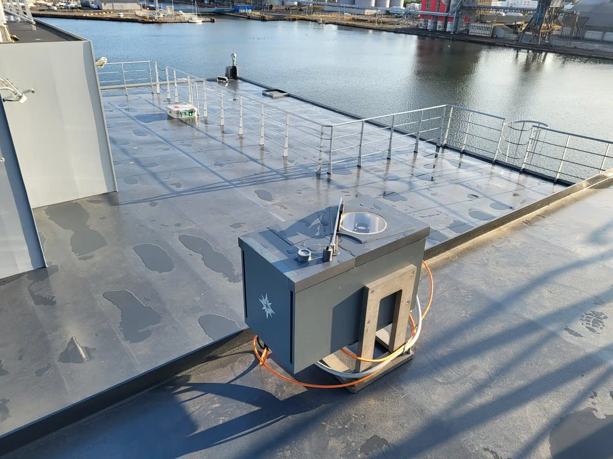
Navigation without GNSS
MAGELLAN allows you to determine a precise position, day or night, without the need for a visible horizon or human intervention. It is totally independent of satellite positioning systems, guaranteeing safe navigation in the event of jamming, decoys or signal loss.
Automated sextant mode
Thanks to an intelligent camera and star-recognition algorithms, the device automatically identifies visible stars and calculates the geographical position without the need for astronomical knowledge or nautical tables.
Astro-Inertial mode
MAGELLAN incorporates an inertial unit calibrated in real time by celestial observation. This mode ensures continuous position tracking, even without sky sighting, with periodic recalibration to maintain accuracy.
Benefits
Navigation without GPS (strategic independence)
Allows you to locate yourself by observing the stars (sun, moon, stars, planets) day and night, offering total autonomy from radio signals and satellites.
Vital in case of jammingof malice or GNSS signal destruction during major conflicts.
Precision and robustness
MAGELLAN combines stellar and solar sighting with inertial navigation: two mature technologies that deliver a restitution of position and attitudewith no need for manual pointing or astronomical knowledge.
The precision of MAGELLAN contains the error within a 200m envelope, whatever the mission duration.
The technology astro-inertial provides an availability rate of 100%.
Multi-domain and dual-use
The need for secure navigation is just as prevalent in the transport sector as it is in the industrial sector. civil of goods and people than for missions military crucial.
The military was a forerunner in development, initially designed for operational needs, Magellan is, nonetheless, suitable for civilians. In recent years, the international context has seen an increase in the number of areas affected. In 2024, more than 46,000 European civil flights were disrupted by failures in their flight control systems. geolocation satellite.
Developed through programs innovation support (RAPID-DGA, Région Normandie, NATO-DIANA), MAGELLAN is a system that has been extensively tested and experimented under a wide range of conditions and on a wide range of carriers (ships, aircraft, UAVs). MAGELLAN is available in a naval and a aerial. The naval version can be integrated on a ship without structural modification. The Aero version can be integrated without modification on the C130 or theATL2in place of the old manual sextant.
Local production and recognized expertise
Designed, assembled and calibrated locally in Normandy (Bretteville-sur-Odon), Starnav is certified ISO 9001 and EN 9100.
STARNAV, a leading-edge technology SME, has been selected by the highly competitive acceleration program DIANA (Defense Innovation Accelerator for North Atlantic) in 2025.
| Features | Detail |
|---|---|
| Category | Astro-inertial navigation system |
| Opto-inertial block | Day and night, integrated IMU, 275 x 230 x 225 mm |
| Computing bay | Circuit unit + time server, 500 x 400 x 250 mm |
| Synchronization | OCXO, drift < 10-8, PTP, PPS + ZDA, |
| Data fusion algorithm | Integrated, unique fusion of position and attitude |
| Positional accuracy | Drift limited to 200m, regardless of mission duration |
| Precision in attitude | 36 arcsec (1 sigma) |
| Data frequency | 100 Hz |
| Availability rate | 100% |
Download the data sheet MAGELLAN NAVAL at English here
Download the data sheet MAGELLAN NAVAL at German here
Download the data sheet MAGELLAN AERO at French here
Download the data sheet MAGELLAN AERO at English here
Download the data sheet MAGELLAN AERO at German here
Magellan's story
Premises
Originating in the earliest ages of human knowledge, astral navigation remained unchanged for centuries. Admiral Desclèves describes precisely how this knowledge was used and transmitted among the peoples of Oceania in the book " the people of the ocean », published by l'Harmattan. Polynesian peoples mastered navigation without instruments very early on. They used the stars as fixed points, memorized their trajectory in the sky, and associated them with directions. In addition to this, they observed swells, winds, birds, and clouds. This empirical knowledge allowed them to travel thousands of kilometers across the Pacific Ocean.
The astrolabe: the first scientific measurement
From the Middle Ages onwards, the astrolabe made it possible to measure the height of a star or the Sun above the horizon. By knowing this angle, sailors could estimate their latitude. This instrument marked a transition towards more mathematical and reproducible navigation.
The sextant: precision and reliability
Invented in the 18th century, the sextant greatly improved the accuracy of angular measurements. It allows for position determination by combining the altitude of celestial bodies with the exact time. For centuries, it became the primary tool for astronomical navigation at sea.
The Era of GPS
At the end of the 20th century, the Global Positioning System (GPS) revolutionized navigation. Thanks to satellites, position can be obtained instantly with great precision, without observation of the sky. Celestial navigation was then gradually abandoned for common use, although it remained taught as a backup solution in case of electronic system failure.
Technological threats and the strong return of astral navigation
GPS (we're talking about GNSS: Global Navigation Satellite System – to account for the various satellite constellations of world powers: GPS: USA, Glonass: Russia, Beidou: China, Galileo: Europe) has become critical infrastructure, but its dependence on satellite signals is also its main weakness. Very weak on reception, these signals can be jammed, spoofed, or degraded by increasingly accessible means. Intentional threats — jamming, spoofing, cyberattacks, electronic warfare — are added to natural or systemic risks: local unavailability, ionospheric disturbances, solar storms, constellation failures, or geopolitical dependence on foreign infrastructure.
This vulnerability creates a clear operational need: to navigate accurately even when GNSS is unavailable, degraded, or compromised. In the maritime, aeronautical, defense, drone, and critical infrastructure sectors, navigation continuity is no longer a technological comfort, but a resilience requirement.
It is in this context that astro-inertial technologies are making a comeback. By combining an inertial navigation system with automatic celestial observation, they allow for periodic recalibration of position and attitude without relying on an external radio signal. The system remains discreet, passive, difficult to jam, and independent of satellite constellations.
Astro-inertial does not necessarily replace GPS; it complements and secures it. It provides an essential layer of robustness in a modern navigation architecture, capable of detecting GNSS inconsistency, maintaining the mission in degraded mode, and restoring confidence in position data.
In the face of increasing threats to GPS, the return of astro-inertial solutions marks a strategic evolution: from high-performance but fragile navigation to resilient, sovereign and operational navigation in a contested environment.
The development of MAGELLAN has made it possible to achieve these objectives.
